![](/images/other/stat-length.png)
![Tour Wintersport Wohlen bei Bern - Wohleibeiz - Photo](https://media.geolcdn.com/t/1900/400/ext.pjpeg?maxdim=2&url=https%3A%2F%2Fstatic1.geolcdn.com%2Fsiteimages%2Fupload%2Ffiles%2F1524743153ski.jpg)
Wohleibeiz
remo
Benutzer
![Länge](/images/other/stat-length.png)
Länge
23 km
![Maximale Höhe](https://static1.geolcdn.com/siteimages/upload/files/1508320355ic_sort_altitude_max_24dp.png)
Maximale Höhe
661 m
![Positive Höhendifferenz](https://static1.geolcdn.com/siteimages/upload/files/1508320355ic_sort_den_pos_24dp.png)
Positive Höhendifferenz
532 m
![Km-Effort](/images/other/stat-length.png)
Km-Effort
30 km
![Min. Höhe](https://static1.geolcdn.com/siteimages/upload/files/1508320355ic_sort_altitude_min_24dp.png)
Min. Höhe
480 m
![Negative Höhendifferenz](https://static1.geolcdn.com/siteimages/upload/files/1508320355ic_sort_den_neg_24dp.png)
Negative Höhendifferenz
589 m
![Boucle](https://static1.geolcdn.com/siteimages/upload/files/16400158638029165_repeat_loop_refresh_sync_direction_icon.png)
Boucle
Nein
Erstellungsdatum :
2014-12-11 00:00:00.0
Letzte Änderung :
2014-12-11 00:00:00.0
![Wintersport](https://static1.geolcdn.com/sitytour/trail-icons/500.png)
--
Schwierigkeit : Unbekannt
![Scannen Sie diesen QR-Code, um die Tour in der SityTrail-Anwendung zu öffnen](https://capi.geolives.com/qq0zvz2zws4bq2lad0pu/sitytour/trails/19260/qr.png?size=200)
Kostenlosegpshiking-Anwendung
Über SityTrail
Tour Wintersport von 23 km verfügbar auf Bern, Verwaltungskreis Bern-Mittelland, Wohlen bei Bern. Diese Tour wird von remo vorgeschlagen.
Beschreibung
Von Wohlen Schulhaus-Oberwohlen-Schüpfenried-Meikirch-Uettligen-Stegmattsteg-Jorde-Gäbelbach-Frauenkappelen-Katzenstieg-Wohleibrücke-Wohleibeiz.
Anmerkung: Es gäbe auch einen direkteren Weg... ;-)
Ort
Land:
Switzerland
Region :
Bern
Abteilung/Provinz :
Verwaltungskreis Bern-Mittelland
Kommune :
Wohlen bei Bern
Standort:
Unknown
Gehen Sie:(Dec)
Gehen Sie:(UTM)
374802 ; 5203149 (32T) N.
Kommentare
Touren in der Umgebung
![Tour Zu Fuß Wohlen bei Bern - Illiswil - Wickacher - Photo](https://media.geolcdn.com/t/375/260/60a1bd14-b657-48fb-bd1f-2ef6d179fb2f.jpeg&format=jpg&maxdim=2)
![Zu Fuß Zu Fuß](https://static1.geolcdn.com/sitytour/trail-icons/100.png)
Illiswil - Wickacher
Zu Fuß
Einfach
Wohlen bei Bern,
Bern,
Verwaltungskreis Bern-Mittelland,
Switzerland
![](/images/other/stat-length.png)
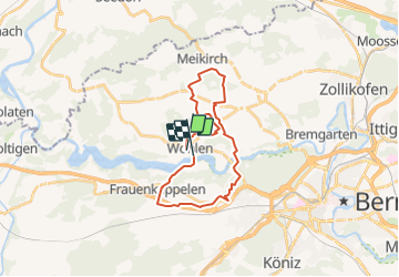
5,3 km | 7 km-effort
1h 35min
![](https://static1.geolcdn.com/siteimages/upload/files/16400158638029165_repeat_loop_refresh_sync_direction_icon.png)
Nein
![Tour Zu Fuß Wohlen bei Bern - Illiswil - Weiermatt - Photo](https://media.geolcdn.com/t/375/260/17e0f03d-022a-4564-a90c-72ed4fe0e52d.jpeg&format=jpg&maxdim=2)
![Zu Fuß Zu Fuß](https://static1.geolcdn.com/sitytour/trail-icons/100.png)
Illiswil - Weiermatt
Zu Fuß
Einfach
Wohlen bei Bern,
Bern,
Verwaltungskreis Bern-Mittelland,
Switzerland
![](/images/other/stat-length.png)
3,2 km | 4,4 km-effort
59min
![](https://static1.geolcdn.com/siteimages/upload/files/16400158638029165_repeat_loop_refresh_sync_direction_icon.png)
Nein
![Tour Zu Fuß Frauenkappelen - Jaggisbachau - Wohlei - Photo](https://media.geolcdn.com/t/375/260/9fd7b831-850e-43f4-8c48-b554ac251ce8.jpeg&format=jpg&maxdim=2)
![Zu Fuß Zu Fuß](https://static1.geolcdn.com/sitytour/trail-icons/100.png)
Jaggisbachau - Wohlei
Zu Fuß
Einfach
Frauenkappelen,
Bern,
Verwaltungskreis Bern-Mittelland,
Switzerland
![](/images/other/stat-length.png)
5,2 km | 8,1 km-effort
1h 49min
![](https://static1.geolcdn.com/siteimages/upload/files/16400158638029165_repeat_loop_refresh_sync_direction_icon.png)
Nein
![Tour Zu Fuß Meikirch - CH-Meikirch - Uettligen/Linde - Photo](https://media.geolcdn.com/t/375/260/6ec6840c-4a23-44d4-a9f7-cb8e4989b02e.jpeg&format=jpg&maxdim=2)
![Zu Fuß Zu Fuß](https://static1.geolcdn.com/sitytour/trail-icons/100.png)
CH-Meikirch - Uettligen/Linde
Zu Fuß
Einfach
Meikirch,
Bern,
Verwaltungskreis Bern-Mittelland,
Switzerland
![](/images/other/stat-length.png)
5,3 km | 6,6 km-effort
1h 29min
![](https://static1.geolcdn.com/siteimages/upload/files/16400158638029165_repeat_loop_refresh_sync_direction_icon.png)
Nein
![Tour Zu Fuß Wohlen bei Bern - Steinisweg - Wickacker - Photo](https://media.geolcdn.com/t/375/260/9fd7b831-850e-43f4-8c48-b554ac251ce8.jpeg&format=jpg&maxdim=2)
![Zu Fuß Zu Fuß](https://static1.geolcdn.com/sitytour/trail-icons/100.png)
Steinisweg - Wickacker
Zu Fuß
Einfach
Wohlen bei Bern,
Bern,
Verwaltungskreis Bern-Mittelland,
Switzerland
![](/images/other/stat-length.png)
3,5 km | 4,4 km-effort
59min
![](https://static1.geolcdn.com/siteimages/upload/files/16400158638029165_repeat_loop_refresh_sync_direction_icon.png)
Nein
![Tour Zu Fuß Mühleberg - Rosshäusern/Station - Riedbach/Station - Photo](https://media.geolcdn.com/t/375/260/92be659b-204c-4274-a3f7-563ebc3a52c1.jpeg&format=jpg&maxdim=2)
![Zu Fuß Zu Fuß](https://static1.geolcdn.com/sitytour/trail-icons/100.png)
Rosshäusern/Station - Riedbach/Station
Zu Fuß
Einfach
Mühleberg,
Bern,
Verwaltungskreis Bern-Mittelland,
Switzerland
![](/images/other/stat-length.png)
3,2 km | 3,8 km-effort
52min
![](https://static1.geolcdn.com/siteimages/upload/files/16400158638029165_repeat_loop_refresh_sync_direction_icon.png)
Nein
![Tour Zu Fuß Wohlen bei Bern - Säriswil - Illiswil - Photo](https://media.geolcdn.com/t/375/260/ext.jpg?maxdim=2&url=https%3A%2F%2Fstatic1.geolcdn.com%2Fsiteimages%2Fupload%2Ffiles%2F1545311037marcheuse_200dpi.jpg)
![Zu Fuß Zu Fuß](https://static1.geolcdn.com/sitytour/trail-icons/100.png)
Säriswil - Illiswil
Zu Fuß
Einfach
Wohlen bei Bern,
Bern,
Verwaltungskreis Bern-Mittelland,
Switzerland
![](/images/other/stat-length.png)
3,3 km | 3,9 km-effort
53min
![](https://static1.geolcdn.com/siteimages/upload/files/16400158638029165_repeat_loop_refresh_sync_direction_icon.png)
Nein
![Tour Zu Fuß Mühleberg - Heggidorn - Fuchsenried - Photo](https://media.geolcdn.com/t/375/260/ext.jpg?maxdim=2&url=https%3A%2F%2Fstatic1.geolcdn.com%2Fsiteimages%2Fupload%2Ffiles%2F1545311037marcheuse_200dpi.jpg)
![Zu Fuß Zu Fuß](https://static1.geolcdn.com/sitytour/trail-icons/100.png)
Heggidorn - Fuchsenried
Zu Fuß
Einfach
Mühleberg,
Bern,
Verwaltungskreis Bern-Mittelland,
Switzerland
![](/images/other/stat-length.png)
3,1 km | 3,9 km-effort
53min
![](https://static1.geolcdn.com/siteimages/upload/files/16400158638029165_repeat_loop_refresh_sync_direction_icon.png)
Nein
![Tour Zu Fuß Mühleberg - Heggidorn - Fuessacher - Photo](https://media.geolcdn.com/t/375/260/ext.jpg?maxdim=2&url=https%3A%2F%2Fstatic1.geolcdn.com%2Fsiteimages%2Fupload%2Ffiles%2F1545311037marcheuse_200dpi.jpg)
![Zu Fuß Zu Fuß](https://static1.geolcdn.com/sitytour/trail-icons/100.png)
Heggidorn - Fuessacher
Zu Fuß
Einfach
Mühleberg,
Bern,
Verwaltungskreis Bern-Mittelland,
Switzerland
![](/images/other/stat-length.png)
3,8 km | 5,4 km-effort
1h 14min
![](https://static1.geolcdn.com/siteimages/upload/files/16400158638029165_repeat_loop_refresh_sync_direction_icon.png)
Nein